Openstreetmap.org and Wikimapia.org are two wiki-enabled collaborative mapping applications that support web user defined geographic content anchored to a common global geo-coordinate system. (ITSRG is among the handful of collaborators for the Philadelphia region, shown in the map above.)
Open Street Map's coordinate system is constructed from data in the public domain such as TIGER Files from the U.S. Census. E-collaborators add content to a global integrated geo-coordinate system base map. The data is "owned" by the community of developers who share in the creation of the wiki.
Open Street Map uses its social wiki to exchange information about technical issues, local users meetings and events, local map projects embedded within the global street map, and resources for broadening participation in the map project. The interface for contributing to the street map wiki is a simple CAD style drawing interface. Data can also be integrated from GPS devices.
Wikimapia differs from Open Street Map in two fundamental ways. First, the application uses Google Maps as the base to which wiki tags are added. Second, e-collaborators are comprised of the entire universe of individuals who have created a wiki tag on the map. In contrast, Google Maps and Earth collaborators access group map content from their individual Google Accounts. Maps projects can be shared among collaborators and they can be made public or kept private among the account-driven collaboration team.
Web 2.0 applications such as Open Street Map, Wikimapia, and Google Maps have the potential to support citizen and community collaborative cartography projects. One of the most important aspects that should be assessed in the determination of which platform is best for a given project is the e-collaborative approach supported by each. Another important factor to consider is the degree to which it matters whether or not the content shared on the maps remains in the public domain. Among the three applications referred to in this discussion, only Open Street Map meets that criteria. Finally, ease of use and ability to support collaboration is also an important factor in fostering participation on mapping projects.
Wikimapia is by far the easiest application to use; although any additions made to the map are susceptible to being altered or removed by others. Google Maps is the most proprietary of the three systems. However, Google's cross platform integration provides a robust solution to the prickly problem of spatial data interoperability across formats and applications. Because of this, many may overlook the concerns about Google's policies on data ownership and use. Open Street Maps is specifically designed as a free and open source of spatial data to both fill in basic information about streets in previously unmapped locales and to connect that information within a unified coordinate system. This is a particularly appealing aspect of the application from the standpoint of community empowerment in that data are in the public domain.
ITSRG has approached the use of Web 2.0 map applications by matching our choices with project contexts and skill levels of those involved in mapping activities. One of ITSRG's primary constituencies has been high school students involved in the BITS Program. Two of the maps projects developed by the BITS students are shared below. The first is our tagging project related to "TempleTown," the North Philadelphia locus of many field activities sponsored by the program. The second is a mash-up that was created using Google Maps depicting the locations of participants in an on-line pumpkin carving competition sponsored by ITSRG and the BITS Program last October.
The aim of the Wikimapia Temple Town tagging project was to introduce students to the core concept of ground truth. They interpreted images online, visited the associated locations, and returned to the computes to add descriptive tags to Wikimapia based on what they observed on the ground. The aim of the exercise was to provide hands on, inquiry led experiences in understanding the limits of satellite and map presentations of spatial information to depict real world geographic information.
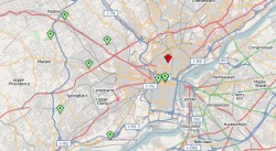
The second map is a mash-up created in Google Maps to show locations of pumpkins carved online and entered into a competition last fall. The map is an electronic footprint of the geographic extent of the viral participation in the competition. The objective was to create a demonstration project that illustrates the impact of using social media applications on the web to disseminate information. We also examined the effects of the project on fostering participation in our community of educational and research praxis related to the societal dimensions of information and communications technologies.
The points on the map below illustrate the geographic extent of the viral marketing campaign the students implemented. The points are tagged with jpeg formatted images of the pumpkins that were carved online and e-mailed to the participant team. We held an event on Temple University's virtual and actual pumpkin submissions, featuring live voting on submitted pumpkins. Winners received online notifications and prizes. BITS program participants concluded the event with a fun workshop for young patients at St. Christopher's Childrens' Hospital in North Philadelphia. The workshop involved training the children how to create and submit an e-pumpkin into the competition. The entire event, including BITS participatns, pumpkin carvers, voters, patients, and staff involved over 300 participants during a three week period of time. Originally posted 6/12/08.
Michele Masucci
Temple University
View Larger Map
 RSS Feed